Josemaria Resources – New Logo

 
Josemaria Resources logo tmn.jpg
 

I am excited to finaly introduce a new logo we designed for a new NGEx spin off – Josemaria Resources.

The logo is inspired by a unique terrain of Josemaria Project that is located in Argentinian high Andes and is based on a fractal interpritation of the switchbacks that are such a distinct visual feature of the location. The colour scheme is a nod to Argentina’s flag.

This logo completes the trilogy (for now) of Andes inspired logos NGEx Resources and Filo Mining.

Josemaria switchbacks inspo.jpg
Josemaria switchbacks inspo 3.jpg

In-Situ Recovery Mineral Processing Plant Illustration for Denison Mines

In-Situ Processing Plant diagram.jpg

One of our long time clients is preparing to advance to production and is working on environmental report. They asked us to create a process flow sheet to explain the In-Situ Recovery (ISR) process chosen for extraction.

Original flowchart supplied along with a floorplan of the proposed plant

Original flowchart supplied along with a floorplan of the proposed plant

Initially they supplied a flowchart, consisting of abbreviations in coloured text boxes, a floor plan of the plant and a link to a website explaining the process. From this information we created a simple pencil sketch keeping in mind previous illustration we have created for investor communication purposes. 

Sketch 1

Sketch 1

The team at Denison assigned a Project Engineer to work with us. We created a rough sketch to send him to confirm our understanding. This proved to be an invaluable step. He responded with a clearly written step by step description of the process and a complete list of the equipment to be used, including some photographs. We then created a new isometric sketch using the floor plan as a rough layout and incorporating more accurate images of the equipment.

After seeing the visual representation of the process in our sketch, the engineering team was able to discuss and fine-tune the details.  Meanwhile, some of the site maps we were working on for the report were using slightly different terminology so this was a good time to standardize all the text to be applied to the reports visuals.

Sketch 5

Sketch 5

After three or four versions of the sketch and all the elements agreed upon we created a clean digitized version, adding shading, colour and line weight to help illustrate the interrelationships of all the equipment. Once the digitized version was delivered, our engineer was keen to share it with management, which sparked a new round of discussion and debate, however only a few minor revisions were requested.

The final ISR process diagram clearly shows the equipment to be used and the mineral’s path from extraction, through the process to market.

Oil Fields Development Concept Illustration

We recently completed this concept illustration for Africa Oil's Lokichar Basin Development. It works as part map, part flowchart. This simplified perspective graphic is a really effective way to show investors all the elements of the proposed development, including the elimination of an on-shore storage and loading facility. Instead, the pipeline will lead straight to a tanker that will be stationed in the port and used as a temporary storage and loading facility. Companies that utilize innovative technologies or creative solutions really benefit from using this style of illustration as investors not only understand how it works but where the advantage lies.

Africa Oil Lokichar Basin Phase 1 development.jpg

NGEx Resources – New Logo

NGEx Resources new logo.jpg

Our long time client, NGEx Resources approached us with a rebranding request. With new and exiting things on the horizon they wanted a stronger, more powerful logo that would signal a pick up in pace to the investor.

Using the success of the logo design for the company’s recent spin-off Filo Mining as a departure point, we revisited the core values of NGEx Resources and their motto ’No Guts No Glory’. The new logo elevates the name NGEx above the high Andes where the company’s projects are located. It plays with the notion of a range of opportunities to explore and develop. The style, reminiscent of vintage mountaineering illustrations, embraces the idea that a combination of hard work, skill and risk are the only path to reach the pinnacle.

Vintage mountaineering illustrations inspiration. 

Vintage mountaineering illustrations inspiration. 

This incredible unaltered photo from Josemaria project shows how truly amazing the colours of high Andes are.

This incredible unaltered photo from Josemaria project shows how truly amazing the colours of high Andes are.

Lifecycle of a mine, recovery of investment, profitability and taxes, taxes, taxes…

Mining Cycle illustration.jpg

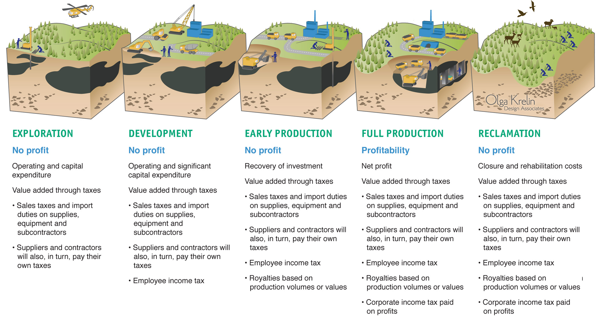
I wanted to share a very interesting graphic that we developed for a client. Exploration and mining are risky business, commodities prices rise and fall, but one thing remains constant… you guessed it – taxes.

While the tax revenue generated by a project grows during development and ultimately peaks during full production certain tax streams are present for the entire life cycle. At all stages, the payments to suppliers and contractors are subject to sales tax or import duty. From exploration to reclamation, income tax is being generated by hundreds of employees. Every company the project does business with at each stage pay their own taxes as do their employees.

When you add in the royalties on production volumes and the corporate income tax paid on the eventual profit, not to mention the corporate social responsibility commitments to local stakeholders it’s no surprise most governments welcome new mining projects. A permit for exploration has the potential to turn into a 20 to 30 year source of tax revenue.

So the mining business must really seem like investing on a geological time scale. Sure an investor can see a return as the share price increases but from the company’s perspective it takes a long time to see that investment recovered and earn a profit. Then some of that profit must be held to cover the costs of decommissioning the mine and reclamation of the site.

Critics of the mining sector focus on profits and the extraction processes, leading to poor public perception. It is valuable to see the entire story in order to help develop social license for future projects.

Exploration mining cycle.jpg

EXPLORATION

No profit

Operating and capital expenditure

Value added through taxes

  • Sales taxes and import duties on supplies, equipment and subcontractors
  • Suppliers and contractors will also, in turn, pay their own taxes

Mine development mining cycle.jpg

DEVELOPMENT

No profit

Operating and significant capital expenditure

Value added through taxes

  • Sales taxes and import duties on supplies, equipment and subcontractors
  • Suppliers and contractors will also, in turn, pay their own taxes
  • Employee income tax

Early Production mining cycle.jpg

EARLY PRODUCTION

No profit

Recovery of investment

Value add through taxes

  • Sales taxes and import duties on supplies, equipment and subcontractors
  • Suppliers and contractors will also, in turn, pay their own taxes
  • Employee income tax
  • Royalties based on production volumes or values

Production mining cycle.jpg

FULL PRODUCTION

Profitability

Net profit

Value add through taxes

  • Sales taxes and import duties on supplies, equipment and subcontractors
  • Suppliers and contractors will also, in turn, pay their own taxes
  • Employee income tax
  • Royalties based on production volumes or values
  • Corporate income tax paid on profits

Reclamation mining cycle.jpg

RECLAMATION

No profit

Closure and rehabilitation costs

Value add through taxes

  • Sales taxes and import duties on supplies, equipment and subcontractors
  • Suppliers and contractors will also, in turn, pay their own taxes
  • Employee income tax
  • Royalties based on production volumes or values
  • Corporate income tax paid on profits

What’s a map progression and why does an exploration stage company need one?

A very common service we provide is auditing maps and designing an investor friendly map progression for exploration and development stage companies. Maps edited specifically for investor presentations or news releases, are powerful communication tools for mining or oil companies.

So how does an exploration stage resource company develop an attention grabbing investor presentation that showcases its assets?

It is important to show all the maps and cross-sections as a clear logical progression, usually starting with the project’s location globally, followed by an area play map, local geology, project boundary, historical context and finishing with detailed plans and sections showing work either planned or completed by the company. All these images are edited to only show the most important elements that are relevant to the company’s story and use color, iconography and typesetting consistent with the company branding.

Global location map of a mining project

Global location map of a mining project

The map progression will usually begin with a country or a continent map, quickly explaining the project’s location. This may be a stand alone graphic if used to introduce the investor to a region or an inset to the area play map.

An area play and infastructure map for a mining project

An area play and infastructure map for a mining project

An area play map will usually contain all available data about the area a project is in, such as infrastructure, any major players with projects in the area, population centers, railways and airports. A mining area play map will usually include a major mineralized trend or belt. An oil area play map will contain oil and gas fields and any existing or proposed pipelines.

General geology map for a mining project

General geology map for a mining project

Next we will usually follow with the local geology map where only relevant geology is shown, plus past and present projects and processing facilities. The infrastructure is usually left off this map.

Mining project map and drill plan edited to show emerging mineralized trends 

Mining project map and drill plan edited to show emerging mineralized trends 

The zoom-in flow of progression is leading to the map of the project boundary that will normally show drilling targets, completed drilling, resource outline or any other details of interest to the investor such as historical or proposed workings or location of processing equipment outlined in a feasibility study.

Mining project and drill plan edited to show areas of exploration potential 

Mining project and drill plan edited to show areas of exploration potential 

Following this there could be a further zoomed in map of the project or various cross-sections showing specific drill results and highlighted intercepts.

Simplified cross section of a mining project with a key showing the location of the cross section

Simplified cross section of a mining project with a key showing the location of the cross section

A resource map progression is a powerful tool to engage the investor’s imagination and show them the answers to the questions they are about to ask. A clear and concise story increases investor confidence in the project.

To see the Piedmont Lithium presentation with our maps click here.

To see the IsoEnergy presentation with our maps click here.

Would you like your maps audited? Give us a call!

Lucara Diamond sells Lesedi La Rona to Graff Diamonds for US$53 Million

Lesedi La Rona with wordmark.jpg

Wow! An amazing Lesedi La Rona  (“Our Light”), the second largest diamond ever discovered, is embarking on the next chapter of its journey. It was sold to Graff Diamonds that also earlier acquired 373 carat diamond that was originally part of "Lesedi La Rona".

It was a great honour for us to be working with Lucara Diamond on branding and marketing this natural wonder in 2016. We created a unique wordmark, ads, invites and commemorative gifts for the series of exclusive cocktail receptions held at five world-class cities to introduce Lesedi La Rona. 

Lesedi La Rona wordmark design.jpg
Lesedi La Rona invite.jpg
Lucara medallions Lesedi La Rona sm.jpg

Deposit development plan for Denison Mines

Final deposit development plan

Final deposit development plan

A very cool 3D illustration we completed this summer. In this type of graphic we remove the layers of geology so the viewer can peek into the earth in a completely unrealistic way. These are some of our favourite projects to work on – it's technical and artistic at the same time. 

The client needed to explain how both deposits will be mined as a single operation. One of the deposits is located above the unconformity, in the soft sandstone and will be mined with the help if the "freeze tent". The other deposit, below the unconformity, will be mined conventionally. We requested as much available info as possible and received various cross sections and models.

Various figures supplied by the client

Various figures supplied by the client

We then do a line drawing and go trough multiple rounds of revisions to arrive at the final drawing.

First we do a simple pencil sketch to confirm with the client that we are on the right track

First we do a simple pencil sketch to confirm with the client that we are on the right track

Vectorized 3D draft with colours, but without shading and textures is sent for approval before final shading is added.

Vectorized 3D draft with colours, but without shading and textures is sent for approval before final shading is added.

Final 3D model illustrated with shading and surface detail. Annotations are the last step left after that.

Final 3D model illustrated with shading and surface detail. Annotations are the last step left after that.

Filo Mining – New Company Logo

We have been getting compliments on our recent favourite project. We could not be happier with how it turned out and the final selection the client made.

Background: Filo Mining is a spin-out of Filo del Sol project that was previously part of NGEx Resources portfolio. Filo Mining is a Lundin Group Company.

Filo del Sol Project

Filo del Sol Project

Concept: Filo means “Ridge” – “sharp ridge” in Argentina Spanish, and “razors edge” in proper Spanish. Sol means sun. Filo del Sol project is located in the Andes and straddles the border between Argentina and Chile.

Inspiration: The client requested to see the sun as one the elements in the logo. The images of mountains at sunrise or sunset immediately came to mind. The distinct Alpine Glow was the main captivating element we wanted to achieve.

Alpine Glow Concept

Alpine Glow Concept

Another point of of inspiration came from the graphic qualities of vintage travel posters. Simple, bold lines create powerful image, easy to remember.

Vintage travel poster. 

Vintage travel poster. 

Final logo for Filo Mining.